MAPS
This is the place to explore some old and some recent maps of Erie County.
Erie County’s Historic Tax Maps provide a wealth of information about each community in our county. You can find block layouts, business details, owners, and so much more. for example:
The 1902 series has information on Groton, Milan, and Margaretta
The 1920-1986 has information on Berlin, Florence, Groton, Huron, Kelleys Island, Margaretta, Milan, Oxford, Perkins, Sandusky and Vermilion. Choose your timeframe 1900 to 2017
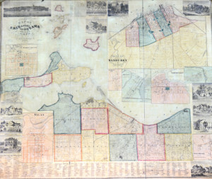
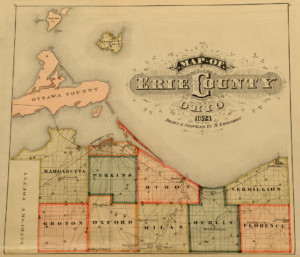 “Map of Erie County Ohio Drawn and Compiled by M. Grosskoff” from Stewart and Page, Combination Atlas Map of Erie County, Ohio, Philadelphia: Stewart & Page, 1874.
It is interesting to note the number of small towns located in Erie County in the last century when the majority of Americans were farmers and dependent upon horses and buggies to reach the nearest town.
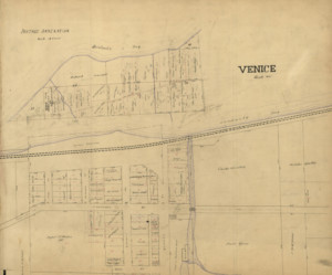
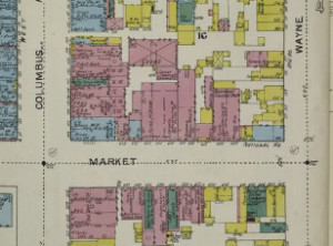 Sanborn Insurance Maps – 1886 and 1893
The Library of Congress has a complete collection of Sanborn Insurance Maps for Sandusky and surrounding areas on their website. Discover what buildings were where in 1893 Sandusky HERE. The city is divided into 42 pages. Page 1 is the overview and tells you which page to go to to see the detail. And 1886 maps can be found HERE.
There is some really cool things in the details. Did you know that the middle of the blocks were usually livery stables and warehouses?
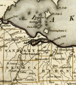
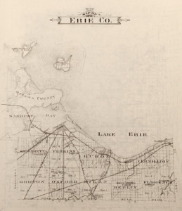 “Map of Erie County” from The Atlas Publishing Company, Illustrated Atlas and Directory of Erie County, Ohio. Including a Directory of the Freeholders of the County Compiled and Published from Official Records and Personal Examination. Battle Creek, Michigan: The Atlas Publishing Company, 1896.
Note the many railroads that connected Erie County with the rest of the United States at a time when people traveled by train and when Huron and Sandusky served as major Great Lakes ports.
 When the Firelands were surveyed by Almon Ruggles in 1809, the area was divided into five mile square townships. Because the northernmost townships bordering Lake Erie were smaller than those to the south, the boundaries of Huron, Berlin and Vermilion Townships were adjusted to make them approximately equal in size to the townships to the south.
 This section of Bradford’s 1838 map of Ohio shows Erie County as it was established in 1838. The new county included Danbury, Catawba Island, and Portage Townships in what is now Ottawa County and Margaretta, Kelleys Island, Perkins, Portage, and Groton and Oxford Townships except for a one mile wide strip of land on the south side of the two townships. In 1840, the three townships on the Marblehead Peninsula became part of the newly organized Ottawa County except for the fragment of Portage County on the south side of Sandusky Bay. Erie County assumed its present form with the addition of Milan, Huron, Berlin, Florence and Vermilion Townships and the one mile wide strip of land in Groton and Oxford Townships bordering Huron County.
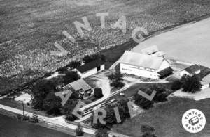 Wonder what your house looked like from the air? Try this site. Currently this site includes aerial shots from 1964-2004. This photo is on the road from castalia to Bellvue.
Vintage aerial maps
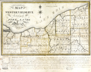 Map of the Western Reserve Including the Fire Lands in Ohio, Published by William Sumner, Nelson, Portage County, Ohio, September 1826.
The fact that Erie County is located in what was known as the Fire Lands of the Connecticut Western Reserve had a significant impact on this area. The town squares in many of our towns, the architecture of our early buildings, and our five mile square townships are all part of our “Connecticut Heritage.”
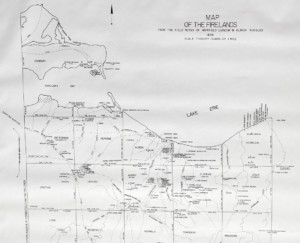
Map of the Firelands From the Field Notes of Maxfield Ludlow and Almon Ruggles 1808: Origin and Distribution of Settlers in the Firelands 1808-1814.
Map of the Firelands From the Field Notes of Maxfield Ludlow and Almon Ruggles 1808: Origin and Distribution of Settlers in the Firelands 1808-1814.
Prior to 1809, modern day Erie County was in the northern portion of the Firelands of the Connecticut Western Reserve. In 1809 the Firelands became Huron County, but it was not formally organized until 1815. This map shows the original township boundaries and names, Indian trails, and the distribution of the early settlers in our area.